Lake WWK monitoring station
Andy Vurma's May 2009 report on the Lake WWK monitoring station:
In partnership with the MNR, the Association has installed a new water level monitoring station in Bennett's Bay, to provide direct information regarding lake water levels. The data from the current water level logger is downloaded infrequently, whereas the new station will provide real time data allowing the height of Lake Wahwashkesh to be known daily.
Although the MNR attempts to moderate inflows of water into our lake, until now the MNR had no way of directly measuring the impact of releasing water upstream into the Magnetawan River on the level of Lake Wahwashkesh. This new station provides this capability. The data gathered (water level, lake temperature, air temperature and rainfall) is now available to the MNR and to our members. Data is downloaded from the monitoring station every 8 hours or 3 times a day.
The partnership with the MNR is for an initial period of about 2 years during which time the relationship between upstream water releases and the level of Lake Wahwashkesh will be monitored. The Association has also agreed to consult with lake residents to determine the levels at which high water is a concern. A review of the data and the input from lake residents on high water levels of concern will take place at the end of the initial period. The Association would then expect the MNR to formally establish water level thresholds for Lake Wahwashkesh as part of the Magnetawan River Operating Plan.
Andy Vurma
October 2008
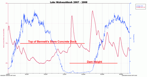
The chart below shows the water level from April 4, 2007 to September 26, 2008. There were dramatic changes in the water level during the summer of 2008 as can be seen by the red-brown line on the graph.
Click on the image below to enlarge it in a new window.
Background
In response to the lack of water level data, the Lake Wah-Wash-Kesh Association purchased a water level logger. Andy Vurma installed the unit in the spring of 2007, and the Association will provide the MNR with water level data on a regular basis. The water level (red-brown line) as well as the water temperature (blue line) will be updated regularly on this Web page.
In early August 2007, the data from the water level logger suggested that there was an error of 0.33 metres in the dam crest elevation based on the survey done of Bennett's concrete deck. After numerous inquiries, this discrepancy was finally resolved on Nov 26, 2007 when MNR's research found that the Benchmark used a long time ago to survey the old dam was in error by 0.33 metres. Consequently, the crest elevation of the dam is actually 225.0 metres ASL. Download the complete 2007 Lake Water Level Report ⇒ ![]() (15 KB) for the full story.
(15 KB) for the full story.
Water levels on Lake Wahwashkesh can easily rise 3 to 4 meters within a few weeks! Wahwashkesh is on the Canadian Shield, which has little soil to absorb water after a rainfall. Therefore, the water quickly runs off into lakes and streams. Wahwashkesh is part of the Magnetawan River System with its headwaters in Algonquin Park. As the river makes its way to Georgian Bay, Wahwashkesh is the last large basin on its course. The lake water has to drain through a narrow gorge (Canal Rapids) where the Magnetawan exits Lake Wahwashkesh; the gorge constricts the flow causing water levels on the lake to rise dramatically. The fluctuating water levels provide Wahwashkesh with its rugged beauty of exposed rock along the shore, where plants are not able to take hold.
The MNR issued the Magnetawan River Water Management plan in 2004, and the report states the MNR used 83 years of data for the study. The Association observed that no actual data for Lake Wahwashkesh was ever used, only estimates based on pro-rating other data. For example, the MNR's report suggested that the water level of Lake Wahwashkesh never drops below the sill height of the rock and crib dam. It is common knowledge that the old rock and crib dam leaked like a sieve, and that the water level of Lake WWK regularly dropped 1 to 2 feet below the sill during the summer. The previous rock and crib dam allowed significantly more water to flow out of WWK than the present concrete dam. In addition, the new dam is narrower than the old one, further increasing lake levels during high flows. The net effect is that this report understated the impact of increased water inflows on the level of Lake Wahwashkesh.
top ↑